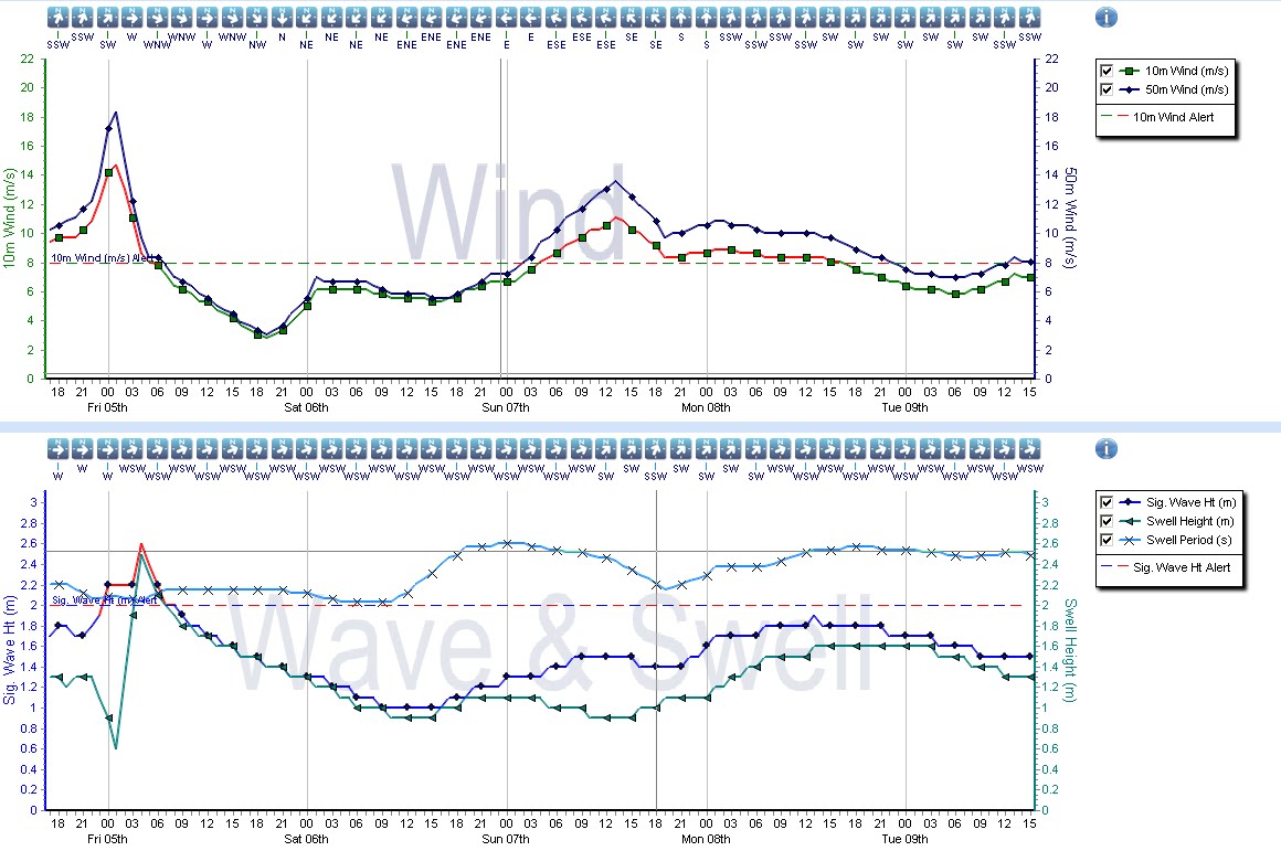
It's proper murky - but there's waves coming, so get up early tomorrow morning, dust the cobwebs off your knackers, and head down the beach.
Here's a wind chart for 0600 tomorrow morning - the tide will be pouring in about then and the wind is perfect. 11 or 12 second swell and just over a meter of open ocean oscillation and a south east wind. No doubt something will throw a spanner in the works but I see medium size perfect waves and the tide lapping in.
Its looking interesting for next week too - with proper swell and maybe favorable winds. 'bout time.
I spend too much time checking weather charts - if I know the surf's going to get good, I'm clicking the refresh button on the web a couple of minutes before the next forecast model gets posted onto the Web. If its looking good then I'll check back again just to make sure. I'm going to blog weather on here and try to explain what's going on. These ramblings will focus on an area from Roche westwards although I reserve the right to go off piste occasionally. All graphics from Metdesk.com
Monday, 8 October 2012
Thursday, 4 October 2012
A big fat splodge of rain is just to the west of the Bishop Rock right now and its moving east - expect to hear the patter of rain all night and perhaps even the lapping of flood water at your heels.
A nice pulse of swell is going to arrive on Saturday afternoon, and last for a few days. Winds look very nice for Sunday too, so there could be a bit of a bonaza if the wind behaves (it's a bit to NE on Sat and too strong on Sun) - its not locked in but there is a lot of promise.
Some of the more tucked away south coast spots that can handle a north-easterly might even light up on Saturday evening and it'll get right up the channel too.
Here is a graph -
A nice pulse of swell is going to arrive on Saturday afternoon, and last for a few days. Winds look very nice for Sunday too, so there could be a bit of a bonaza if the wind behaves (it's a bit to NE on Sat and too strong on Sun) - its not locked in but there is a lot of promise.
Some of the more tucked away south coast spots that can handle a north-easterly might even light up on Saturday evening and it'll get right up the channel too.
Here is a graph -
Friday, 28 September 2012
Shun...
Don't say i didn't warn you - that low from the last post did some bad things alright -
I've been hunkered down - tending to the family and am now resurfacing and autumn is well and truly here - the Atlantic has stoked up the boiler and is now pouring out some nice beefy lows - the south-westerly will be upon us for much of the weekend and most of next week, so it'll be big and bouncy along the main beaches with the usual nooks and crannies producing the goods.
From late next week, it's looking like that high pressure will build over the near continent (and there is some pretty good agreement with the models here) which will back the wind southerly towards next weekend. This could mean a proper long period, deep ocean swell is going to materialise at last, something there hasn't been for a very long time. Nadine, a hurricane which has been sloping around near the Azores for yonks, may also get tangled up in a depression late next week, to add a little brown sauce into the proceedings.
I'm not getting too excited yet but watch this space.
THURSDAY
Note TS Nadine there mooching with intent
FRIDAY
....and now Nadine engaging with the upper trough
SATURDAY
...pouring on the sauce
SUNDAY
MONDAY
I've been hunkered down - tending to the family and am now resurfacing and autumn is well and truly here - the Atlantic has stoked up the boiler and is now pouring out some nice beefy lows - the south-westerly will be upon us for much of the weekend and most of next week, so it'll be big and bouncy along the main beaches with the usual nooks and crannies producing the goods.
From late next week, it's looking like that high pressure will build over the near continent (and there is some pretty good agreement with the models here) which will back the wind southerly towards next weekend. This could mean a proper long period, deep ocean swell is going to materialise at last, something there hasn't been for a very long time. Nadine, a hurricane which has been sloping around near the Azores for yonks, may also get tangled up in a depression late next week, to add a little brown sauce into the proceedings.
I'm not getting too excited yet but watch this space.
THURSDAY
Note TS Nadine there mooching with intent
FRIDAY
....and now Nadine engaging with the upper trough
SATURDAY
...pouring on the sauce
SUNDAY
MONDAY
Saturday, 22 September 2012
Go West
It will be interesting to see how much swell gets in on the north-westerly swell that's passing by the west of Kernow tomorrow - the wind's in the right direction to make it nice if it appears - It's coming in on a NNW dirn rather than NW so it is probably going to miss the western fringe of cornwall and head down into France - It'll start to show after luncheon (give or take a few hours) IF it arrives - i'm not really that hopeful. I've seen similar stuff light up the coast all the way to the Camel, but i dont think this is one of these swells.
There's a hoolie blowing up in the Bay of Biscay too - the forecasters are looking to cyclogenisise a low pretty heavily over the coming 24 hours and then swing it up over the UK - looks pretty grim to be honest - and will be the first decent blow of the autumn through Mon and Tue - Conker time.
Tuesday, 18 September 2012
A not bad run of waves coming up
I think it'll be small and clean from Thursday through the weekend - perhaps one of these swells where there is a lot of waiting around, but with the odd peeler which is a notch bigger than the background swell. Winds are looking decent til sat too.
One for the log i think, which hasn't seen a lot of the sea for a while and that will know doubt mean some sketchy rides!
noon sat By Sunday afternoon there is also a good chance of a much beefier and more interesting swell arriving from the NW - it's come from high up in the Atlantic and also a little too far east to drive it up the Cornish coast thanks to Ireland being in the way. The models don't (historically speaking) do a particularly good job of wrapping this swell in, and i am hopeful that if the wind plays ball that there is some potential. The different forecasters are also all over the place with the prognosis for Sunday mind, and in all likelihood it'll be howling onshore.
One for the log i think, which hasn't seen a lot of the sea for a while and that will know doubt mean some sketchy rides!
noon sat By Sunday afternoon there is also a good chance of a much beefier and more interesting swell arriving from the NW - it's come from high up in the Atlantic and also a little too far east to drive it up the Cornish coast thanks to Ireland being in the way. The models don't (historically speaking) do a particularly good job of wrapping this swell in, and i am hopeful that if the wind plays ball that there is some potential. The different forecasters are also all over the place with the prognosis for Sunday mind, and in all likelihood it'll be howling onshore.
Saturday, 15 September 2012
Hurricanes - we like
Ooooh, well that wasn't too bad then was it. The wind stayed nice and light this morning and there was more than enough waves to share around.
Eyes down for later this week too - its a little tricky to pull out the detail at the moment but the picture is that there is a hurricane out there and most of the forecasts have some long period swells buried somewhere in the forecast spectral plots.
There is a hurricane out there and here's where it will be on Tuesday according to the European forecasters -
Note there is a lot of calm sea between west Corn and the hurricane and this is a good thing. The type of swell you get from these kind of storms are High period swells with a low wavelength which get easily disrupted if there is a lot of local wind. Conditions look nice for the swell to run in underneath a high to the west of Corn around Weds or Thurs and then last for several days - it is a little difficult to give more detail than that as the spectral partition data from the American forecasters is currently more than 36 hours old, tainted with that 28second glitch i referred to a couple of days ago and there are multiple pulses and swells and quite a bit of divergence in the various models too.
Confused?
Let me simplify it - I reckon there could be waves later in the week, smallish but nice ones. Light offshore late Weds through to Fri - perfect for gliding on the log and enough to get the short-boarders frothing on Thursday.
Eyes down for later this week too - its a little tricky to pull out the detail at the moment but the picture is that there is a hurricane out there and most of the forecasts have some long period swells buried somewhere in the forecast spectral plots.
There is a hurricane out there and here's where it will be on Tuesday according to the European forecasters -
Note there is a lot of calm sea between west Corn and the hurricane and this is a good thing. The type of swell you get from these kind of storms are High period swells with a low wavelength which get easily disrupted if there is a lot of local wind. Conditions look nice for the swell to run in underneath a high to the west of Corn around Weds or Thurs and then last for several days - it is a little difficult to give more detail than that as the spectral partition data from the American forecasters is currently more than 36 hours old, tainted with that 28second glitch i referred to a couple of days ago and there are multiple pulses and swells and quite a bit of divergence in the various models too.
Confused?
Let me simplify it - I reckon there could be waves later in the week, smallish but nice ones. Light offshore late Weds through to Fri - perfect for gliding on the log and enough to get the short-boarders frothing on Thursday.
Thursday, 13 September 2012
This weekend...
There was some excitement earlier in the week but this is now tempered by unco-operative high pressure systems bringing an onshore wind this weekend.
Plenty swell on Saturday and I think the session of choice will be Saturday first thing, as it is then, when the wind will be lightest and closest to the south. Its not ideal but will probably be worth a sniff.
Subscribe to:
Posts (Atom)