Monday, 17 April 2023

Spring...

Plenty of swell filling in today for the Cornish North Shore today with the wind puffing gentle offshore all day.


Plenty of swell leftover Tuesday and strong east winds... 


The Big low out there will fill in over the next 48 hours as a strong Scandinavian high intensifies and spreads it's wings towards Shetland and the Faeroes midweek and then link up with the Greenland high. Strong northern blocking like this will set up a pretty aggressive negative - NAO which will serve to keep what low pressure development there is later in the week on a southerly track. 

Smaller Wednesday, and tiny on Thursday and strong easterlies will dominate southern UK Tuesday through to the Friday . 


The next system to watch is the one west of Brest on Thursday...
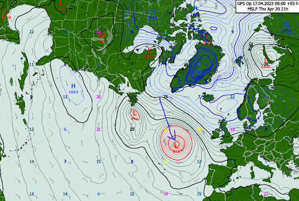

This should pulse some swell into the west and up the channel for the weekend, but right now it is probably over deepened, and it's anyone's guess what the wind'll be doing by then.  


Wednesday, 12 April 2023

Hiatus...

It's been a while - I'm starting this up again. 

Today looks like a bumpy ride across the SW of the UK. Lots of isobars and stormy conditions spreading eastwards. 


Forget tomorrow, NWerlies and tonnes of swell. 

Friday is not a brilliant start, as the upper trough moves east across the UK dragging behind strong west winds. In the evening, this will crank round to the north, perhaps opening up some options on the south coast but there is a high degree of uncertainty at this point as to whether this happens before it goes dark.  


The good news is that the broad area of strong winds to the east of the UK will push a lot of swell up the Channel for Saturday and with north winds it could be a classic down south! Solid and offshore and decent right up the Channel. 


The swell will drop back a notch on Sunday and it now looks like the wind might just get around to the SE for much of the day as high pressure builds in from the east and low pressure continues to churn out in the central Atlantic.  


Early next week will be good or very good as the wind swings SE'erly and opens up the North Shore from Monday. Good model agreement between the Americans and the Europeans, so confidence is high. 


Thursday, 25 August 2016

Friday, 13 February 2015

The early bird catches the worm.

The nights are lighter and this morning the sun was up not long after 0600. I reckon you can be in the water well ahead of 7 and that's precisely the plan for tomorrow. Heavy weather on the other side of the pond has kicked up a heck of a lot of snow and a fairly decent, long period swell pointed straight at the south coast. Been watching it all week...

This afternoon's rain from a low crossing the UK will clear overnight and a nice NNW wind flow will set itself up in its wake. 

TONIGHT

DAWN TOMORROW


Only one place to be if you ask me - and that's the Jurassic coast and the long walk out to the mighty Broad Bench.  

Lets hope there aren't many others around with the same idea. 

Monday looks interesting too. 


Tuesday, 21 October 2014

Gonzales

A draughty old day thanks to hurricane Gonzales. 

Our satellite imagery picked up some cracking images as the storm wound up to the west of the UK and swung out into the North Sea. 

YESTERDAY


TODAY


At one o'clock, Gonzales' remnants were out in the North Sea and a north westerly gale was blowing  a hooley across all of Britain in its wake. As you'd expect, the really big gusts were tangled up with the showers. 

The white numbers show the peak gusts. 


Dunno if anyone found any waves.


Saturday, 11 October 2014

Big and bouncy


A pretty little dartboard will emerge in the NAT over the next two or three days. Weighing in with a low of less than 955mb it'll be packing a serious punch. The swell's likely to peak on Thursday at around 8-9 feet and 15 or 16 secs so expect most places to be maxing out and the wind'll be howling in from the south. Big, beefy and in all likelihood a lot of work. 

Find the right tucked away spot and you'll score. 

I'd expect Mr Crib to be dusting off his knackers and start throwing some shapes too. 


Tuesday, 23 September 2014

Return of the Low.

The Atlantic seems to have woken up a little this week - Low pressure is back on the scene and it's a pretty good picture on the run up to the weekend. This week's lows are nicely positioned - high in the Atlantic and mobile enough to extend their influence over Cornwall, bringing in a fresher feel and westerly winds through Wednesday and Thursday, before high pressure ridges in across Fastnet through Friday. 

Wednesday 


Thursday

There's some uncertainty on exactly how quickly the ridge will develop on Friday with the EC model wanting to drop it to no more than a feint zephyr by late arvo and it could glass off nicely in the evening. Fingers crossed here. 

Friday 


The main bulk of the swell isn't destined for us but there'll be a manageable groundswell over the weekend and a nice south-easterly breeze to keep things nice and clean. 

Saturday

Saturday 


Sunday


PS how many waves in a set were there last Sunday. I counted 18 on one set!!! The last 4 or 5 peeled through unridden. 

Thursday, 18 September 2014

Saturday

High noon wave period on Saturday - 


Choose carefully where to go as the wind has a little bit of a northerly component. 


Sunday, 14 September 2014

Steady Eddy


Hurricane nomenclature is a bit silly. This latest one's been given the name Edouard which is almost impossible to spell. It's in the western tropical Atlantic at the moment, doing the meteorological foxtrot and the best the computer models can tell us right now is that it'll continue to beef up for the next couple of days before heading east towards us. 

By Thursday it'll be here -


Friday here ...

...And by Saturday it'll have lost its identity. 

This is likely to bring a decent pulse of long period swell towards Corn which'll hit some time Saturday afternoon and last for a couple of days. I like these kind of swells, nothing too hectic, 3-4 foot, meatier sets and plenty of time to paddle out. 


Saturday, 13 September 2014

Big and beefy

This kind of thing has been lurking in the depths of the forecast charts for a few runs now. It's a ghastly brute, with about a 1% chance of happening... 


Thursday, 11 September 2014

North or South

Nice southwesterly swell this weekend. Reckon it'll be a bit tastier than the charts suggest. 

Hopefully there'll be enough east in the wind to get the Cornish riviera pumping. 

If not, the north won't disappoint

Fill the car with juice


Tuesday, 26 August 2014

A plop in the ocean


Over the last week or so there has been some changes to the upper air patterns in the Northern Atlantic - a number of bigger depressions have hooked into the jet stream and it looks like at long last that a decent run of waves could be on the cards. It's been several months since there's been a genuinely decent prognosis but I reckon there'll be at least one and maybe two really nice September swells over the coming fortnight. 

Both have their origins in old tropical storms... 

Number one swell - locked in nicely and very likely to happen....


Number 2 swell - a lot less certain on the detail... 


Add caption


Tuesday, 12 August 2014

Not much on the horizon


If you've got time on your hand and don't mind the schlep, the east coast might be worth a sniff early next week.


Beyond that and we have to venture into the long range forecast where things aren't reliable to get excited - 

This is about the best I can muster. 


Wednesday, 6 August 2014

Eyes down ladies

It's been a while since a chart like this has appeared in the forecast horizon and with 15 days to go before its supposed to happen, its unlikely to actually happen. It's not quite the PERFECT forecast chart, but near enough and if it comes to fruition then a few days off will almost certainly be on the cards. 


Tuesday, 5 August 2014

Big Bertha

Bertha's out there and looks like fattening herself up nicely over the next couple of days. At this stage in the game, its impossible to know exactly what'll, happen but I like this solution from ECMWF. 

50-60mph winds and waves on the south coast in August. That'll be a fine thing.  

Monday, 21 July 2014

Nice little swell on the way...

Looks like last week's prophecy stands a pretty good chance of coming to fruitition. 

Nothing huge but of good enough size to get more than a little excited about. 

Here's the swell in its infancy...


Wednesday morning dawn patrol looks like the choice session as the sea breeze will probably be on it come mid morning. 

And here is the wind when the swell arrives. 


Tuesday, 15 July 2014

It's been a while and this is the first update from my ipad so I haveno idea of how good the formatting will be.

There's not been a massive amount to get excited about of late, a few scraps here and there. South-easterly winds haven't seemed to be on the agenda, and when they have it's been a case of no swell. Typical Cornish summer I hear you say. However, there's a storm brewing out in the slot later this weekend and this should swing some waves our way during the middle of next week. Early days for any detail, but there's more than a good chance of winds either being light or offshore at the time the swell arrives and some real waves might be on there cards.


Monday, 4 November 2013

If ...

.... you like surfing along the south coast, then be sure to bookmark this chart. 0600 this morning,

Booming from the Harbour Wall in Penzo all the way up to Dover.


Sunday, 15 September 2013

September aint been a classic but ...

... the eagle eyed chart monster's among us will have started heavy breathing, stripping off, slathering ourselves in honey then getting the dog to lick up the mess today.

A seriously classic set up is looming so you had better clear the decks for the the end of the next weekend.

Hurricanes in the middle of the Atlantic are a pain in the arse to forecast, but the detail right now is about 50-65% in favour of SE winds and a pretty decent long period burst of swell coming in from a WSW direction sometime between Sunday afternoon and Monday morning, depending on what model you look at.

So here is the latest version from the 2 big model providers

EC is a little slower, to develop the low - see below and doesn't ramp up the low until Sunday.
.

GFS hurtles the low past the UK by the end of the weekend.


Both sets of models have the same scenario but, the timings are different, don't get too busy at the end of the weekend or early next week...


BEYOND that looks good too.