Saturday 29 December 2012

Poogers

There has been plenty of frolicking over the past week or so and also some not bad waves if you are prepared to put some mileage in to find the. Shamefully I don't surf the south coast much these days, as when it is good its a mighty fine place to be - especially this time of year when the wind is veering and backing like a fiddler's elbow.

It never ceases to amaze me that the same faces I used see around 20, and in some cases 25 years ago are still pounding the backroads between the Texaco garage in Snorstul down towards Veryan. I wonder how much petrol has been wasted over the years hunting around for scraps? Wonder if they'll still be doing it in another 25 years?

I can't remember the water being so warm around christmas time and I was happy as Larry for a few hours this afternoon with no boots, nor hood, nor gloves. Lots of bird action as well, think there was some sort of midwinter petrel and shithawk symposium the other side of Black Head as that's where they all seemed to be going.

2012 won't go down as a classic year I don't think - there was nearly 6 months with hardly any south-easterly wind from March through to September and I reckon that must go down as one of the worst spring/summer periods since (my) records began.

The winter storms of the last few weeks will continue for the next few days but there looks like being a big change just after the new year beds in.

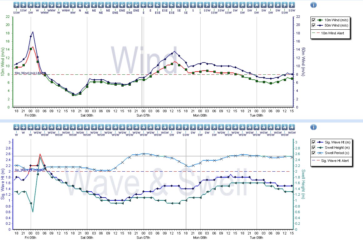
Before that though, the south coast is going to bowl one mighty last over and I'm having trouble stopping my trousers from bulging.

The American forecasters show dream south-coast charts - a pretty decent south-westerly hoolie, and a decent sw swell ahead of a big isobar elbow creeping east through Monday afternoon.

Mon Morning

Noon Mon


So the rough plan for Monday - As soon as the rain stops, wheel spin out of Polgooth and turn left on the Meva road.
 
Spect Levvie will be heaving too and there will be some leftovers on NYD I think.  

Friday 21 December 2012

Good week

Blimey - what a week - hopefully I've brought home some bacon this week, and oh boy, what lovely waves in Spain. Me and one other out at one stage, the day before was allegedly the best it has been for years but you won't hear me complaining.

King of the Goblins
Thanks to Peggy for the photo lending me a towel. Wish I could have stayed as there looks like plenty more to come - They buggers off to Morocco tomorrow for some xmas, waves must be foaming with excitement.

Back here, the pattern looks locked down for at least the next week as a deep, entrenched upper trough sits to the west of Ireland - this will bring low after low and strong winds, not to mention the a bathtub of rain. Most of the next week the wind will be whistling in from the south-west, so its a case of tucking in out of the wind,  but it will be veering and backing from time to time and this might make the main beaches and perhaps the south-coast worth a sniff. Monday and Tuesday are perhaps the most interesting looking days, as there are hints of some disruption to the main upper trough and perhaps the development of a smaller system turning the wind more southerly on Monday.


 Meanwhile, fronts moving through on Christmas morning may swing it northwesterly in the afternoon so the south coast could have a short offshore window. Nice way to burn the turkey off.


Sunday 16 December 2012

EggNog

Some not bad waves in the last week or so and some big units crashing in over the weekend if you were prepared to tuck in away from the wind.

I think that's going to be the story of the next week or so - There'll be waves alright but getting detail on the wind and when it will be offshore is going to be tricky in such a mobile scenario. Tuesday afternoon is probably the next decent window for some nice waves - in fact it's looking pretty classic.


It's also way to far out for any confidence but if the current set of charts from the weekend workout, then the south coast is looking pretty sexy just ahead of Christmas - might have do my shopping early and off the eggnog.

I've managed to score a work trip to the Basque country this week and am hoping to be able to swing by Mundaka - winds are forecast to be berthing in from the south-west so I have everything crossed. Camera will be at the ready so I hope to upload some pics. I bet it's pumping now - SW wind, 11 foot and 16 seconds. Same on Friday - Deep Breath!

Monday 10 December 2012

OH dear, what can the matter be,

... three old ladies got stuck down the lavatory,
the wind was south easterly from Tuesday til, Friiiiiiiday
lalalalalala la  la

or something like that anyway.

What better way to start the week than with a forecast of southeasterly winds from more or less tonight until the end of the week - it will get pretty wild out there towards the end of the week, as the gradient tightens ahead of the next load of flooding and wild weather this weekend, but there should be plenty wave coming.

The best swell is most likely to be the Tuesday and Thursday, with Thursday getting into a range which will be getting the big waves spots raising the eyebrows.


Friday 7 December 2012

Logs on the fire

I'm a notch more confident about next week now - several runs of the magic swell machine and Tuesday and Wednesday aren't looking too shabbuth. A nice neat pulse of swell and a lot more east now in the wind than north so pencil a couple of afternoons off and get down the beach.


spot the ball

After that and it might get into the big & beefy range for the end of the week/weekend - the Atlantic is threatening to kick up a stir and return the westerlies, with big fetch, big wind pointing big swell right into the north shore. I suspect it'll be a howling mess but if the high over Scandinvia can hang on in there and keep the wind southerly, as some of the ensembles suggest, it could get interesting.


12 out of the 20 ensemble members below all want to keep the wind sourthely next weekend - that's more than half  - 14 and 19 look particularly nice!

Thursday 6 December 2012

had forgotten about this...

...r, c and me shaking the bumptee - s on camera. 


The Siiiiiidewinder


Brrrrrr


If you don't mind surfing when it is utterly freezing, then next week is going to offer up some pretty decent waves I think.

Here's the Atlantic chart from ECMWF on Sunday - a nice low berthed up in the middle of the Atlantic and the ridge I was talking about earlier in the week snuzzled down over the UK. Meanwhile, flipping cold air is nestled in over Scandinvia and with a general easterly flow that means it'll be icy. It's not the most powerful low, nor is it aligned in the best place way but I think there's some good potential that will get waves into the medium sized range by the middle of next week.


The wind direction has some work to do to, it's a little too north of east for my liking at the moment but only by a fraction, but it will be offshore all along the Aardvark's nose so you might have to go west to get the best.


Monday 3 December 2012

The north-westerly jet


A north-westerly jet is currently blasting us with a low pressure system every few days, with each successive low that comes through ploughing in with a howling northwesterly. Sooner or later, high pressure will settle over the north Atlantic and then it'll get cold perhaps even really cold as the radiators get switched off.

that's the theory anyway...


NW'ly low #1 (the jet is running in a rough line between Iceland and Les Alpes). 


NW'ly low #2 (jet in the same place)


#3 - and note by this time the high pressure ridges between Iberia and Iceland are linking up as the jet weakens. 


Now its blocked... the jet is gone gone elsewhere and lows are stopped from coming from the west and it'll then get cold


Good for south-easterly wind mind - these kind of patterns are great when it comes to forecasting long range and long periods of south-easterly winds. With luck, swell generators will tuck a couple of long range high period swells in under the south-easterly winds and fingers crossed these might get into the midium sized range at some point

Friday 30 November 2012

A view from the top

Lots of nice snow in the Alps - Meribel - with a foot of fresh pewd and the soleil shining. 


lolop

Barely a breath of wind this morning and nice little swell. 

mmmm

Monday 26 November 2012

North

Kiss goodbye to autumn as winter is coming - be sure to chip the crust off of the willy warmer and make sure there's enough logs outside the backdoor. North winds will dominate the weather over the coming week, which more or less kills any hope of a decent wave.

Go and find something else to do, like going to the Alps - I have no idea if anything is open yet but if it is, I'd wager there'll barely be a soul to be seen, nipple deep powder to be had and my choice would be the western Italian Alps first thing Thursday morning.


Wednesday 21 November 2012

Brrrrrrrrr

Loads more wind tomorrow before it calms down again later on Friday. Then it gets interesting - A hot stepper will sidle north-east from the Bay of Biscay overnight and into Saturday morning, but ahead of it will be a lot of slack air which will eventually brisken up to produce a south-easterly wind. The track, speed and intensity of this low are being hotly debated amongst the different forecast models right now. The wind might slacken enough on Friday evening but I think it's now a little more certain that Sat, first thing, will have a SE'ly breeze before gets windy again later in the morning. It's a small window and likely to be at its best when its dark unfortunately, but the dusky hunter or the early worm might score one in the bushes.


This low is an interesting one, as it will disrupt the westerly flow we've seen coming in off the Atlantic this past few weeks. After is whizzes though the pattern changes to a wintry one, as the upper trough moves from the Atlantic, across the UK into the North Sea putting the UK under a NE flow and more depressingly, on the cold side of the Jet.

Next week, the consensus seems to be that the same NE flow will draw in some proper bad boy cold air from Lapland.

Hiatus

Nice little south coast wave this morning - wind calmed down overnight and a little swell on the south coast. Not huge but niiice. 


Tuesday 20 November 2012

Windy

Good weather for wind farming - if you are a fan of renewable energy then this week marks a week where more clean, green, fuel free energy has been delivered to the National Grid than ever before. Move over Nigel Farage this is marvellous news. I think the record will be broken again on Thursday when the next bout of strong winds cross the country. The forecast was 100% spot on earlier in the week too, lets hope the same can be said on Thursday.

There's been some good sessions over the weekend and some of the nooks and crannies have been pumping, and will continue to pump through the week (as soon as you don't mind wind of course). The pattern will change over the weekend as the big upper trough out to the west of the UK fills in and moves east. There might be a slot on Saturday with offshore winds but otherwise it's the nooks and crannies who'll be delivering.

As you can see, there is quite a difference in the surface wind forecasters for Saturday - the top one is usually the most reliable and most favorable so fingers crossed. There'll be 3-4 foot swell tucked in underneath the wind so if it does go offshore, then party time. (i'd give it a 30% change at this stage)


 .

Friday 16 November 2012

what happened to the Sun?

The surf's still nice this morning but it's a lot smaller - the dreaded kicks in from about 2100 tonight then it'll stay that way - NWerly all day tomorrow...

...and then the scenario changes to a much more mobile scenario for next week - the jet is going to strengthen to the west of the UK while high pressure sits motionless like a fat turd stuck down the bog in western Russia - this will strengthen the gradient in the West Country, as successive fronts and bands or rain dive east. There'll be waves, and quite big ones I think, but it will be a struggle against the wind. There will be calmer moments when the wind backs south or south easterly and backs off and these will be the windows to look for but there its too early right now to give the detail other than hinting that Wednesday morning looks most favorable at the moment. Otherwise, the nooks should deliver the goods.


Wednesday 14 November 2012

more waves....

Well its been boofing through today that's for sure - and there is at least a couple more days of very nice waves to come - the size will drop steaily through the next 48 but there'll be plenty to be getting along with. 


Winds will turn onshore and over the weekend but there is good agreement from the different model providers and also the ensemble forecasts that from that from Tuesday next week that the wind is going to be purring back in from the south accompanied by more solid swell. 

Monday 12 November 2012

Looks like its locked and loaded.

It'll be too big for mere mortals I suspect, if you cast your minds back a couple of weeks, the big swell of the 20th peaked at 14seconds and 1.8m or so - this one looks like about 13 seconds and 2.5m+ swell so it'll be interesting to see what transpires.

Winds look perfect, so i suspect there'll be some nice pics of the Cribbar, while the main beachies will probably be maxing out.  


Friday 9 November 2012

Beef

More big waves look like coming - I suspect it will be bigger than it was last time around by a notch or two but the wind is a little less certain at this point. Cusping in a notch west of the south at this stage.

<BR> This is the brute which is going to produce the waves...


And depending on what model output you are looking at, the swell looking like peaking sometime on Wednesday. Could be awesome if the wind behaves.


Wednesday 7 November 2012

Weird rat plays the Sax.

Unless you're off south this next few weeks there's barely any point looking at any weather charts.

Thursday 1 November 2012

rubbish

Back to square one again. Ridge out in the Atlantic, north to north-west airflow and not much hope of anything remotely surfable.

Best to get the head down and concentrate on something else.

Ad infinitum Ad infinitum Ad infinitum Ad infinitum Ad infinitum Ad infinitum Ad infinitum Ad infinitum Ad infinitum Ad infinitum Ad infinitum Ad infinitum Ad infinitum Ad infinitum Ad infinitum Ad infinitum Ad infinitum Ad infinitum Ad infinitum Ad infinitum Ad infinitum Ad infinitum Ad infinitum Ad infinitum Ad infinitum Ad infinitum Ad infinitum Ad infinitum Ad infinitum Ad infinitum Ad infinitum Ad infinitum Ad infinitum Ad infinitum Ad infinitum Ad infinitum Ad infinitum Ad infinitum Ad infinitum Ad infinitum Ad infinitum Ad infinitum Ad infinitum Ad infinitum Ad infinitum Ad infinitum Ad infinitum Ad infinitum Ad infinitum

Wednesday 24 October 2012

way-ah

After all the fun of the fair down in Cornwall last weekend, there's a boom shanker coming down the North sea this weekend. It's more or less a dream set up with a tight pressure gradient aligned north-south to the west of Norway through Thu and Fri, with low pushing its chest out on Saturday evening to turn the wind offshore. The local crew up there will be foaming at the mouth no doubt, and it looks worth the (long) trek.


That's it for a while after that - high pressure looks like ridging out to the west of the UK, in a rough line from the tip of Greenland to Iberia and its looking entrenched so don't expect to be surfing or sunbathing any time soon.

Tuesday 16 October 2012

le boeuf

I have had me eye on this for a while now because i thought the wind was going to be too strong offshore but, I am now coming around to the idea that this weekend is going to be rather stupendous.

The swell will build big style during Saturday, and turn into a full blown swell with a nice juicy offshore wind.

Here's the swell - - top panel swell in cm - bottom panel period in seconds


And here is the wind.

Thursday 11 October 2012

Big and bouncy

There is some interesting weather coming up in the next 10 days or so - a huge upper trough will develop on the eastern side of the Atlantic and the Jet will be roasting along up at the 200mb level.

The upper trough looks like one of those ones where at some stage a rather nasty low will run along the channel and do some damage to some dustbin lids and caravan parks.

If you can tuck in behind one of these lows somewhere along the south coast i suspect you'll be in business but the window will be small and timing will be everything.


next week - I should have thought there'll be some decent waves to be had in the more tucked away spots on the north coast too.

Monday 8 October 2012

Arise

It's proper murky - but there's waves coming, so get up early tomorrow morning, dust the cobwebs off your knackers, and head down the beach.

Here's a wind chart for 0600 tomorrow morning - the tide will be pouring in about then and the wind is perfect. 11 or 12 second swell and just over a meter of open ocean oscillation and a south east wind. No doubt something will throw a spanner in the works but I see medium size perfect waves and the tide lapping in.


Its looking interesting for next week too - with proper swell and maybe favorable winds. 'bout time.

Thursday 4 October 2012

A big fat splodge of rain is just to the west of the Bishop Rock right now and its moving east - expect to hear the patter of rain all night and perhaps even the lapping of flood water at your heels.

A nice pulse of swell is going to arrive on Saturday afternoon, and last for a few days. Winds look very nice for Sunday too, so there could be a bit of a bonaza if the wind behaves (it's a bit to NE on Sat and too strong on Sun) - its not locked in but there is a lot of promise.


Some of the more tucked away south coast spots that can handle a north-easterly might even light up on Saturday evening and it'll get right up the channel too.

Here is a graph -

Friday 28 September 2012

Shun...

Don't say i didn't warn you - that low from the last post did some bad things alright -

I've been hunkered down - tending to the family and am now resurfacing and autumn is well and truly here - the Atlantic has stoked up the boiler and is now pouring out some nice beefy lows - the south-westerly will be upon us for much of the weekend and most of next week, so it'll be big and bouncy along the main beaches with the usual nooks and crannies producing the goods.

From late next week, it's looking like that high pressure will build over the near continent (and there is some pretty good agreement with the models here) which will back the wind southerly towards next weekend. This could mean a proper long period, deep ocean swell is going to materialise at last, something there hasn't been for a very long time. Nadine, a hurricane which has been sloping around near the Azores for yonks, may also get tangled up in a depression late next week, to add a little brown sauce into the proceedings.

I'm not getting too excited yet but watch this space.

THURSDAY
Note TS Nadine there mooching with intent


FRIDAY
....and now Nadine engaging with the upper trough


SATURDAY
...pouring on the sauce


SUNDAY


MONDAY

Saturday 22 September 2012

Go West

It will be interesting to see how much swell gets in on the north-westerly swell that's passing by the west of Kernow tomorrow - the wind's in the right direction to make it nice if it appears - It's coming in on a NNW dirn rather than NW so it is probably going to miss the western fringe of cornwall and head down into France - It'll start to show after luncheon (give or take a few hours) IF it arrives - i'm not really that hopeful. I've seen similar stuff light up the coast all the way to the Camel, but i dont think this is one of these swells.

There's a hoolie blowing up in the Bay of Biscay too - the forecasters are looking to cyclogenisise a low pretty heavily over the coming 24 hours and then swing it up over the UK - looks pretty grim to be honest - and will be the first decent blow of the autumn through Mon and Tue - Conker time.

Tuesday 18 September 2012

A not bad run of waves coming up

I think it'll be small and clean from Thursday through the weekend - perhaps one of these swells where there is a lot of waiting around, but with the odd peeler which is a notch bigger than the background swell. Winds are looking decent til sat too.

One for the log i think, which hasn't seen a lot of the sea for a while and that will know doubt mean some sketchy rides!

noon sat
By Sunday afternoon there is also a good chance of a much beefier and more interesting swell arriving from the NW - it's come from high up in the Atlantic and also a little too far east to drive it up the Cornish coast thanks to Ireland being in the way. The models don't (historically speaking) do a particularly good job of wrapping this swell in, and i am hopeful that if the wind plays ball that there is some potential. The different forecasters are also all over the place with the prognosis for Sunday mind, and in all likelihood it'll be howling onshore.

Saturday 15 September 2012

Hurricanes - we like

Ooooh, well that wasn't too bad then was it. The wind stayed nice and light this morning and there was more than enough waves to share around.

Eyes down for later this week too - its a little tricky to pull out the detail at the moment but the picture is that there is a hurricane out there and most of the forecasts have some long period swells buried somewhere in the forecast spectral plots.

There is a hurricane out there and here's where it will be on Tuesday according to the European forecasters -


Note there is a lot of calm sea between west Corn and the hurricane and this is a good thing. The type of swell you get from these kind of storms are High period swells with a low wavelength which get easily disrupted if there is a lot of local wind. Conditions look nice for the swell to run in underneath a high to the west of Corn around Weds or Thurs and then last for several days - it is a little difficult to give more detail than that as the spectral partition data from the American forecasters is currently more than 36 hours old, tainted with that 28second glitch i referred to a couple of days ago and there are multiple pulses and swells and quite a bit of divergence in the various models too.

Confused?

Let me simplify it - I reckon there could be waves later in the week, smallish but nice ones. Light offshore late Weds through to Fri - perfect for gliding on the log and enough to get the short-boarders frothing on Thursday.