Monday 4 November 2013

If ...

.... you like surfing along the south coast, then be sure to bookmark this chart. 0600 this morning,

Booming from the Harbour Wall in Penzo all the way up to Dover.


Sunday 15 September 2013

September aint been a classic but ...

... the eagle eyed chart monster's among us will have started heavy breathing, stripping off, slathering ourselves in honey then getting the dog to lick up the mess today.

A seriously classic set up is looming so you had better clear the decks for the the end of the next weekend.

Hurricanes in the middle of the Atlantic are a pain in the arse to forecast, but the detail right now is about 50-65% in favour of SE winds and a pretty decent long period burst of swell coming in from a WSW direction sometime between Sunday afternoon and Monday morning, depending on what model you look at.

So here is the latest version from the 2 big model providers

EC is a little slower, to develop the low - see below and doesn't ramp up the low until Sunday.
.

GFS hurtles the low past the UK by the end of the weekend.


Both sets of models have the same scenario but, the timings are different, don't get too busy at the end of the weekend or early next week...


BEYOND that looks good too.


Monday 9 September 2013

A ticket to paradise -

There's quite a bit of churn in the forecast, and not everything agrees, but this chart looks pretty sexy down west, even better if you happen to be in France. 

Chunky swell and no wind.

Yes please.
 

Friday 23 August 2013

September Beckons

September, (the best month of the year) is just around the corner. '96 and '97 were a great vintage, offshore, sunny and loads of swell.

I'm starting to cast a keen eye on the back end of the forecast charts as there's been some interesting signals that high pressure is going to dig in across the English Channel, and with lots of action high up in the Atlantic things could be looking nice. It's a way off but one to watch I'd suggest. Mmm Proper waves.

Monday 15 July 2013

Roasting sunshine

It's been hot.

With a lot of sun.

... and not many waves for the last week.

Not much hope for the next week either.

Might be a dab of swell at the weekend - no more than a dab mind, and almost certainly you'd be better off down on the south coast with a spear gun or a boat hunting the mighty Bass.


Tuesday 2 July 2013

SuMM£r

Wooooooo yeah -

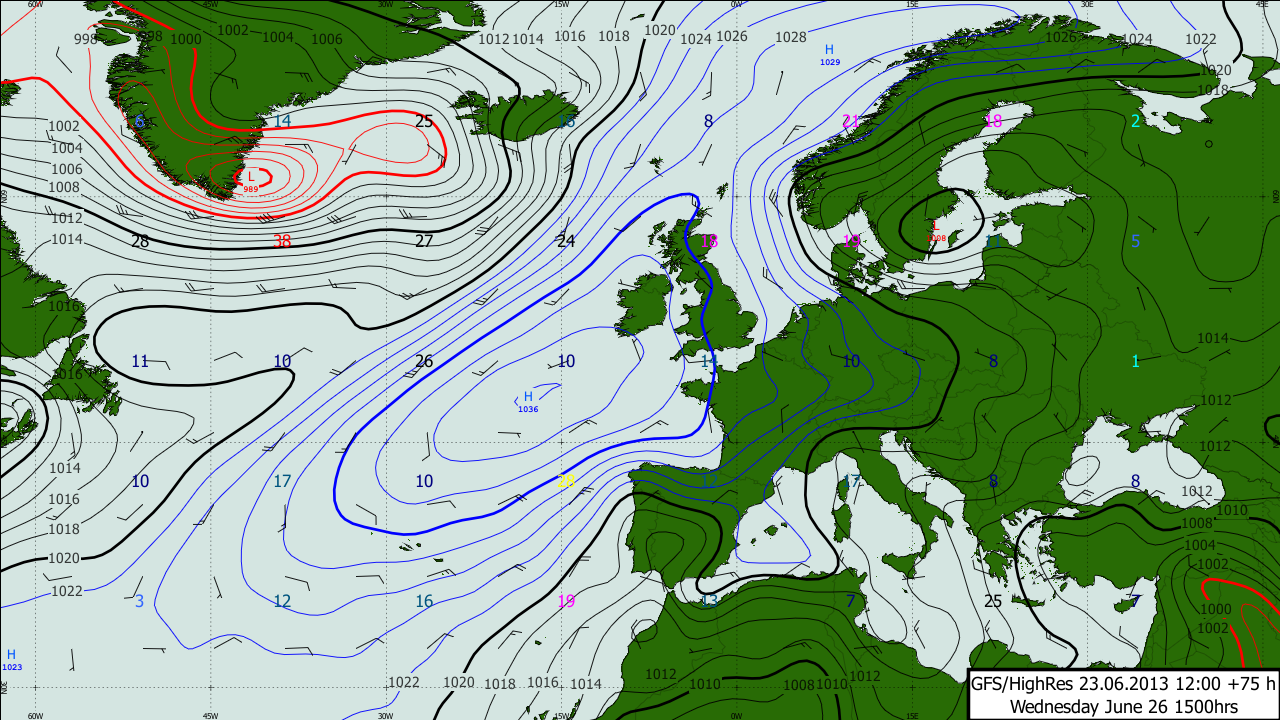
Look below at the position of the Jet Stream in the images below - it's the purple bit, and it's the stage upon which wild weather haunts the corridors. Right now it's over the UK and rain is upon us. During the last few summers - this has been the theme - westerly winds - lows - deluges - wind, and generally pretty crap, depressing weather and last summer in particular, chronic waves.


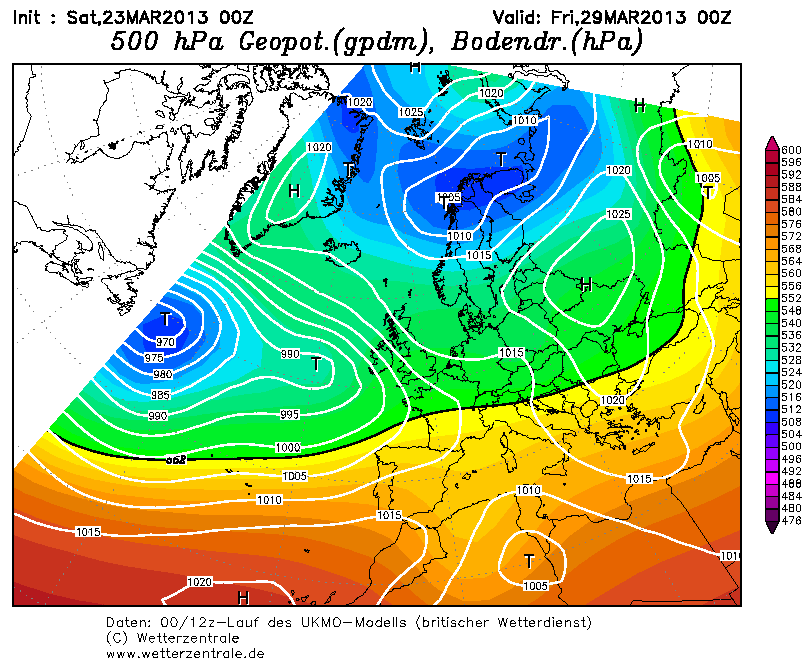
Well, things are on the rise - and there's going to be a big change ahead of the weekend - The jet is going to head north, way north and let the good times roll in from the south. It's been threatening to happen for a while now, as the position of the Azores high has been comfortably further north than recent summer's.


Looks like its going to stay there for a few weeks too.

Here's the chart for the weekend.


Meanwhile, this low below will bring plenty wave to the north shore on Friday.


And look - mmm - the wind is looking sexy first thing Friday- ie not a scrap of it.


Smaller on Sat, but there'll be another half decent decent pulse of waves on Sunday, I think, and the wind will be equally as nice. 


The fly in the ointment is could be sea fog but hey ho. 

Monday 1 July 2013

Sunday 23 June 2013

Azores high is back

After all the huff and puff of this weekend - things look like calming down nicely this week, as high pressure sets out its towel on the beach and looks set to hang round for a bit. I think it will be a slow process before it warms up, as it will build in from the W, rather than the south-west, but anything has got to be better than this past weekend. You know the weather's shite if you've been surfing the South Coast in June.

Pretty much all week, there'll be a NW wind and there's enough going on up around the NW Atlantic to make things look interesting around the weekend. But one thing to watch is Tuesday morning - as low pressure leaves and before the new high establishes itself, there'll be a spell of rather slack wind and a couple of feet to be getting on with, maybe even the odd three footer, so if you can find a nice bank and a log before breakfast, I'm sure there'll be some fun.


Wednesday's Atlantic chart above shows the next developing situation - it's not ideal - the main pulse of the swell from the Low near Greenland isn't going to be going to be thrusting towards Corn, but there may be a bit of spatter coming our way, so the weekend is certainly worth a sniff at this stage. Especially as the European forecasters want to pull the centre of the high across Southern England and into the Channel by Sunday, and that will make for offshore winds on the north shore.

Here's high noon on Sunday.


Sunday's a long way off, so this forecasts will probably be totally wrong but it is worth keeping an eye on.

http://www.metdesk.com/?page_id=1123

Friday 14 June 2013

Sunday looks promising

There's been quite a bit of change to the detail since earlier in the week.

Here's the picture now -


The current windy and wet weather is kicking up some fairly short period but half decent sized waves quite near to the UK - which will last through the weekend and into Sunday.

Way up in the sky, the Jet is roaring...


.. so its all very mobile, and at the surface Sunday morning looks interesting as the wind will swing to the SE as a new swings rapidly in from the Atlantic - there's a slot in the morning before the wind picks up which looks the most tempting.


I'm thinking 3-4 foot and a nice offshore wind so worth getting up early.


Thursday 13 June 2013

New App from MetDesk

If you are interested in dodging rain, then please check this out.


It's only 69p.

Tuesday 11 June 2013

Pretty grotty...


Well that's it for the warm sushine for a while. After a couple of weeks of sunshine, the Atlantic has charged back into life, and depressions going to cross the UK. There's a broad area of low pressure out there, with a series of not very nice looking depressions developing on the southern flange and rattling up across the west country and Ireland. 


The flow is broadly SW'ly for the beginning of this week, so there will be waves heading in from the west of Portugal, and these will most likely become quite large from the middle of the week. It's a mobile scenario, and there's hope that the wind might nudge just the right side of southerly to make something happen on Friday. It's touch and go though. 

After that it's anyone's guess really, but Sunday might just be offering up a calmer day - at at the moment there's consensus of the wind backing into the SE to clean up what ever's left of the swell. One to watch, as if this scenario pans out as per the current charts, there'll be 4-5 foot of swell with 10 or 11 seconds going right up the Channel and both coasts will be getting some nice ones. 


Friday 31 May 2013

Woop.

What more can a man ask for but a light wind, puffing gently offshore, wall to wall sunshine and swell peaking at about 13 seconds and 4-5 foot or so.

Tuesday and Wednesday will be delivering.

Make the most of it, as the North Atlantic will then shut down I fear.


Monday 13 May 2013

It's been a while...

... Been out of the game for a while sorting out a few odds and ends with work and all that, but that's all done and dusted now and hopefully I'll be able to beef out some of the content on this blog over the coming months ahead, as my new line of work gives me access to some wide-wheeled, high octane forecasting content. (as per below)

I might even stick some automated content up here if I get the time, but that might take me some time.

Follow it all at www.MetDesk.com

In the meantime, after a several days of cracking spring sunshine, the weather's broken and there now looks like being an extended period of not very nice, cyclonic conditions with the wind predominantly wavering around between SSW and NNW, ie cool, maritime, shower and rain conditions.

Here's tomorrow


There'll be very little to get the boiler stoked if you are in the market for pumping offshore surf.

The upper air pattern and the position of the jet, looks depressingly like the scenario that developed last April and then lasted all summer and into the autumn. ie tonnes of rain and cool temperatures.  Fingers crossed that get disrupted in the short term.

Here's what the jet's doing on Monday and Tuesday. (pink over UK is bad)


Saturday 23 March 2013

Brrrr

Winter just won't bugger off. Great Britain's King of weather statistics, and custodian of the truth when it comes to putting current weather into a long term perspective - Mr Philip Eden, runs this interesting site.  http://www.climate-uk.com/graphs/201303.htm The CET is a temperature data set which has been going for donkey's years and March 2013 will almost certainly end up right down there, towards the very bottom of the series.

The waves are back this weekend, I had meant to stick up a heads up earlier in the week but I've been too busy. The swell is probably peaking about now, and will fade overnight to leave small swells and offshore winds just about the whole of next week. Offshore, that is, with a lot of easterly in it and that means more cold weather to tinkle with your goolies.

By about Wednesday, a low starts to pick up some momentum in Atlantic and this will bring some pretty decent swell in for the weekend. It's still early days for the detailed forecast but if the current prognosis pans out it'll be roast beef with all the trimmings. Confidence is pretty high as there is good alignment with the UK European and American models that

1. the low develops
2. high pressure holds firm over Scandinavia to keep the wind south-easterly over the bank holiday.

I've got a week off and plan to make the most of it.


Right I'm off down the allotment to plant some spuds, before heading down the beach.

Sunday 10 March 2013

cant see anything remotely interesting on the horizon...

.... After a seemingly endless run of offshore wind and swell, that that's now it, time to get on with something else. Call me a bender if you like, but how cold was that wind this afternoon?
<BR>

After a session in the freezer this week, high pressure looks like returning to the worst place it can be - blocked in the mid Atlantic by the weekend, with sloppy areas of high pressure over the UK ruining everything. 
<BR>
Rubbish.


Thursday 28 February 2013

A pretty decent run of surf all in all...

... There's another couple of pulses of dingish waves to come, one tomorrow and over the first bit of the weekend and another Tuesday and Wednesday next week.

Then, I think towards next weekend, the big bugger of a blocking high which has been the king pin to all this puming surf there's been, gets a punture and wilts back from whence it came -

The westerlies are back next weekend, with rain and spring temps.

So here lies the difference.

This Friday
Next Friday

Pretty epic while it lasted, and if anyone finds my gloves (last seen in Bude, or perhaps Kimmeridge) please let me know.

Wednesday 13 February 2013

Magic south-east wind from the king of the weather goblins.

This time of year the weather pattern often changes and I reckon late Feb/early March has always been a good time to take some time off work. Through Nov, Dec and Jan there is still a big temperature gradient between the poles and the Equator in the northern hemisphere, and this is what big storms and the jet steam thrives on. As winter evolves, the temperature gradient slackens as the whole hemisphere cools slowly, so by the time we get into February, the potential for massive storms diminishes and by March the potential for blocking highs to settle across N Europe is good. The key to getting some waves out of this slacking boils down to where the high settles in. Too far south and the wind is westerly over the UK, too far east and it'll be NW'erly, too far west and there's no swell. Ideally highs  settle over southern Scandinavia or the German Bight and when that happens it paarrrday time as the pressure gradient will be moving air from Brittany up to Cork. It's what hapepned in the epic spell in March 2012 and there's more than a 50/50 chance of this happening next week.  

avnpanel 500 hPa

Me likes. 


Tuesday 12 February 2013

A run of ace surf coming up (perhaps)

Looks like high pressure over S Scandinavia is going to do the business from the weekend onwards.

Light south-east winds and long period swells.

avnpanel 500 hPa

Saturday 26 January 2013

Deep dipper

You don't get lows as low as this often. 930mb - I was speaking to one of the top brains at ECMWF at a wind forecasting shindig in Paris during in the Autumn he was taking about the big Atlantic storms being every bit as devastating as the tropical hurricanes. If this beast would have been travelling through the English Channel or through Biscay into Northern Europe it would be remembered as a storm of notable proportions and probably have gone on to swipe dozens of people from the planet. Thankfully then, its whirring away where it should be, miles from anywhere and the worst the hurricane force winds at its epicentre are doing is whipping up an almighty swell. 

This is the lunchtime surface analysis from the German Met Office (DWD), hand drawn and a magnificent piece of work if you like these kind of things. 


It's a beast alright, and there is some serious rain on the way over the next fortnight or so, as the south-westerlies conveyor up moist warm air from the subtropics. The surf options look like being simple - it's a case of heading around the corner up here in Cornwall or head somewhere further south and soak up the longer period juice for a week or so (the chance would be a fine thing). The north Africans will be having a field day. 


Sunday 20 January 2013

Good weekend then tonnes of swell...

Decent weekend by most accounts, with the wind nestling in from the east - I got stuck in the snow.

Monster swells on the way over the next 10 days or so, starting tomorrow. A whole bunch of nutters will no doubt be taking on the mighty Mullag and the forecast couldn't be much better. Will be interested in seeing the footage if anything materialises.


Big westerly swells for much of the week 


.. and then more monster lows towards the weekend  =  945mb. 


Then a reload early next week 


Thursday 17 January 2013

Nearly everyone I know seems to have either disappeared off somewhere else, or is just about to - skiing, tropical paradises, Morrocco, central America and Norfolk. More the fool them I say, as there's been some good waves around and more to come.

The jet has his foot on the hammer over Nova Scotia, (see purple bit on the map below) and with lots of cold air driving off north America, a big unit will develop in the central Atlantic - some charts say as low as 950mb. 

The jet will dive south over central Europe next week after what could be a nice weekend with light, perhaps offshore winds and a slowly dying swell.  


GO LOW


There will be some big stuff early next week and the wind hasn't made its mind up yet where it will be blowing from, but there is more than one model, and some back up from the ensembles (see charts from below) suggesting offshore winds on Monday, for when the swell is peaking - one to watch closely over the weekend. 


After that, its looking promising - as well. Everything looks like calming down and the wind should turn SE'ly later next week. 

Give me Cornwall any day. 

It's going to start Neigeing

If you like snow and then go away from Cornwall. 


Monday 7 January 2013

Sexy Beast


Attention everyone.

Nice Juicy Bum.
Long legs.
Soft olive skin. 
Bright red lips.
Rosy cheeks
Bright blue eyes. 
Pearly white teeth. 
Plump hooters. 

Hardly anything on, covered in bovril, flicking the bean and ready to get pumped. 

Without wanting sound too mysogenistic, if the forecast for Wednesday was a woman - that's what she'd be looking like. Hot as f*&k and ready for action. 

6 foot, 13 secs and a light south-east wind.

Rubber up.  


Sunday 6 January 2013

Not a bad set up...

Plenty wave in the last couple of days, and more today, although it does look a bit wibbly wobbly this morning, but with a bit of effort and perhaps a bit of trailing around, I reckon there's oats to be eaten.

It's quite a complicated scenario this week - apathy has taken over pressure systems and nothing really seems to be taking control - there's a whole load of flabby lows, and sprawling highs drifting across Europe but also some swell generators out west - the current swell will hang around through today and tomorrow, at about the same size but Tuesday will be smaller I think.
Generally, (at least for the first part of the week) the wind will remain in the southerly quadrant

Wednesday looks nice - barely a scrap of wind after a new swell fills in overnight. Could be some decent waves and some lovely sunshine.


Beyond that, and it looks like getting colder - the Europeans bring super cold air from Estonia, the Americans try to do the same but later and less cold, while the MO looks like developing a growler out west with a general downward trend in temperatures.

I was looking some charts on Friday and there were some pretty good indications of a warming of the Stratosphere - this is linked with a weakening or evening a reversal of the polar vortex which tends to have a dramatic effect on temperatures - it is likely to be a cold second half to Janvier i suspect.


Wednesday 2 January 2013

Ploop

At about 8.30 on NYE's a human chain of revellers and lots of booze came down a spiral stair case in deepest darkest Cornwall. I was a couple of bottles of Crabbies in, but for one reason or another I pulled off the back of what could have been a hefty session and ended up being pretty much the only person to the west of St Austell who escaped without a hangover on New Years day. Good job, as the sun was up and the wind offshore - Apart from climbing into a sopping wet suit, a perfect start to the year.

The New Year marked a big change in the weather too - for the time being at least, the relentless strong wind and rain will be replaced by light south winds and some sunshine by the end of the week. 

There are also some decent swell generators out in the drink too - think 1.5 to 2m and 12-14 seconds, pretty much constantly from now 'til early next week - plenty big enough for most at this time of year.

FRI

Y


I suspect over the weekend it will get pretty decent but just watch for the wind nudging around to just west of southerly at times. 
SAT

SUN


MON